STATION PADRE: EXPLORING THE ENVIRONMENTAL AND GEOSPATIAL FEASIBILITY OF A PLATFORM-BASED OFFSHORE AQUACULTURE FARM IN THE SOUTHWEST GULF OF MEXICO
The continental shelf waters of the Gulf of Mexico are highly industrialized, with 1,800 oil and gas platforms across the region. The rising number of decommissioned platforms (about 175 yr-1) has resulted in an expansive network of unused offshore infrastructure, which has the potential to be repurposed into multi-use MMEERSET (Marine Monitoring, Energy and Environmental Research, Science Education and Training) stations. In this project, our team worked to assess two platforms of interest near N. Padre Island, TX (site Station Padre) to determine the environmental and geospatial suitability of site development for offshore aquaculture farming.
A Nortek Signature 500 current profiler unit (ADCP) was deployed in 51 m of water from July 3rd - August 6th, 2020 to collect data on current direction, velocity and wave height. The significant wave height was between 0.35 - 1.40 m with maximum waves between 0.39 - 2.81 m during normal conditions. During the deployment, Hurricane Hanna passed over the study site , which saw a maximum wave height of 10.39 m and a significant wave height of 6.22 m, which exceed ed 4 m for over 24 hours. The parameters measured are characteristic of highly exposed, open ocean conditions with a mean near surface current of 0.23 m s-1 and mean significant wave height of 0.89 m. Any aquaculture infrastructure installed on site will need to withstand this high energy environment and submersible infrastructure is highly recommended.
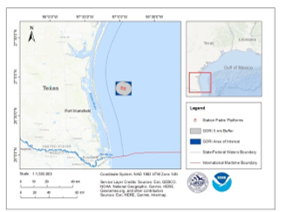
A regional geospatial analysis was conducted in ArcGIS using NOAA's AquaMapper geodatabase . Station Padre is located 35 miles NE of Port Mansfield, TX at a water depth of 155 ft. Temperature ranged from 18- 29 °C, salinity maintained at 35 ppt, and dissolved oxygen > 4.7 mg l-1 . Mean current ranged from 0.05 - 0.2 sv with a m aximum current of 0.75 sv and mean wave height of 1.3 m. Wave energy period, wind direction, light attenuation, nutrient profiles, and benthic composition were also assessed. Station Padre is located within a Military Operating Area, which covers an extensive portion (30,000 sq. km) of the northwest GOM. Additionally, platforms are located 80 and 215 m from a shipping fairway, which transects the Area of Interest . Shipwrecks, artificial reefs, and hard bottom habitat are located no closer than 6.6 km from the platforms. Site characterization revealed favorable conditions and it was determined that 77% of the Area of Interest represents Opportunity Area for future farm development.